Friday, September 20, 2013

Day 2 - Roncesvalles to Larrasoaña - 27.4km

Today's route was mostly in well wooded country, on easy gradients through several valleys: first the rio Urrobi, over the ridge Alto de Mezquiriz, across the rio Erro, over another ridge (Alto de Erro) and then along the rio Arga.

This could be the most photographed sign on the Camino.  The distance commonly quoted for the most popular of the routes, the Camino Frances from St Jean PdeP to Santiago, is 790 km.  I'm not sure how accurate that is, or whether the distance by road from Roncesvalles to Santiago is really 790 km too, but everyone gets a shot of the sign, even those of us who walk past in the dark at 7.21 am (some fellow pilgrims' shoes just visible glowing in the camera flash).
I walked with Ralph for the first part of the day, and our first stop was at the busy Cafe Fronto in Auritz (Burguette) for breakfast, since there wasn't anywhere open in Roncesvalles at the time we left.  The cafe is located on the central village square filled with well manicured plane trees, right next door to the imposing facade of the Iglesia de San Nicolas de Barri (below).


Rain spoiled play somewhat for much of the day, but the sun did come out later.  Note to self: waist pouch is not very waterproof - soggy tickets and a disintegrating wallet are the not too serious results - but the backpack rain cover works very well, thank goodness.
A symmetrical feline welcome in Linzoain.


A view from Alto de Erro
The Puente de la Rabia, a medieval bridge over which the pilgrim can cross the river Arga into Zubiri, is thus called because of the legend that leading an animal three times around the central arch will cure it of rabies. Well perhaps.

Based on the Brierley guide book's recommendation, we bypassed the industrial town of Zubiri, with its wide choice of private and municipal hostels and pensions, and headed instead for Larrasoana. After crossing or passing several medieval puente and spotting trout rising in the streams, finally the magnificent church bells of Larrasoana appeared.

The municipal albergue had several attractions which the guide book left out, including rickety bunk beds in the annexe, mouldy, cobwebbed ceilings a few inches from my face (I had to make do with a top bunk) and a shortage of toilet paper.  There wasn't much choice for dinner, but the only bar/cafe in town did serve an acceptable pilgrim meal, and I stocked up on bread, chorizo and sardines at a local shop for a picnic lunch the following day.


Thursday, September 19, 2013

Day 1 - St Jean Pied de Port (France) to Roncesvalles (Spain) - 25km

I made an early start on that first morning, after a restless night - almost bang on 7am - nervous and unsure of how I was going to manage the distance, the climb, the weather.  I wasn't anything like the first out of the blocks, though.  Dave from the US, with whom I walked and chatted with a few times over the next few days - is passing through the archway immediately after the church entrance.

As I climbed through the foothills and it got lighter, there were glimpses of views back into France, and by the time I reached the auberge at Orisson (was that really only 8 kilometres?) a light drizzle was falling, so a cup of tea was very welcome.  A third of the day's target done, and I haven't collapsed yet - there's hope!

When I resumed walking, the foot traffic had increased noticeably- many pilgrims spend the night at Orisson to get a head start on that first day - and I got a measure of how one is never alone for very long on the Camino.
As I climbed, the drizzle came and went, the mist pretty constant.  This is what much of the first day of the Camino looked like. Sadly not a grand view, but to be honest I'm not sure how much I would have noticed. I was trying too hard to breathe to concentrate on much else.


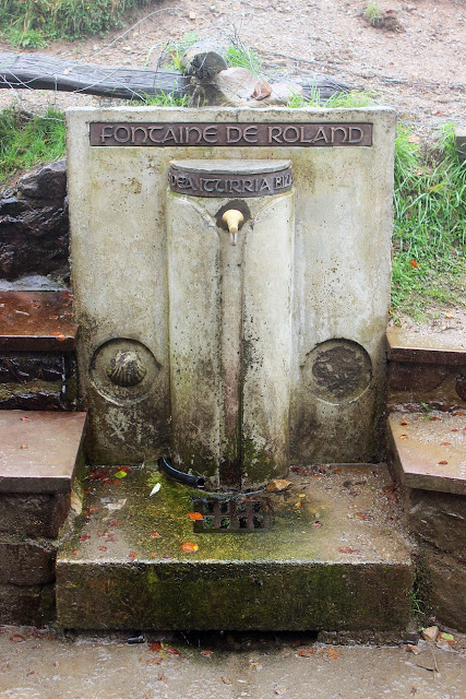
The last stretch up to the highest point at Col de Lepoeder (1450 metres) was through both open and wooded terrain - very pretty in spite of the lack of a grand view, and I got a second wind.  I filled my water bottle at the Fontaine de Rolande, and proceeded up the now rather muddy track past the stone marker into Navarre (16.7 km).  Two-thirds of the journey done - I was tired and absolutely soaked - from perspiration rather than the rain - but at least the end was in sight, figuratively speaking at least.

From there the track went steeply downhill through tussocky slopes, and then finally through a picturesque beech forest along a valley to Roncesvalles.  Spent the last hour or so trying to keep up with a very fit guy named Ralph from Frankfurt.

The hostel in Roncesvalles is a newly renovated building with almost 200 beds - very modern, smart and clean, and run efficiently by Dutch volunteers.  After a very welcome shower and getting my clothes washed, I spent the afternoon lying on my bed resting. Then enjoyed my first "Pilgrim Menu" - including grilled baby trout trunchetta and red wine - in a restaurant nearby, getting to know Ralph, Dave and a couple of Japanese pilgrims with very little English.  Another early night - establishing a routine.

Wednesday, September 18, 2013

El Camino de Santiago - Registration Day in St Jean Pied de Port

The Camino de Santiago, aka The Way of St James, is actually a collection of traditional pilgrim routes through Europe all ending at Santiago de Compostela in north-western Spain. My decision to walk the most popular of these routes, the Camino Frances from St Jean Pied de Port (SW France) to Santiago, was made in July this year, and I left for Europe about six weeks later.

Sylvie and Jacques Baylaucq on Rue de la Citadelle, St Jean Pied de Port, after looking after me for a day in Biarritz and driving me to the start of the Camino. They could not have been kinder and more welcoming hosts for my first visit to the south of France. Thank you both, and I hope that one day I'll be able to repay the kindness.

Satellite view of part of south-western France and northern Spain showing the route of the Camino de Santiago, from St Jean Pied de Port on the north-eastern side of the Pyrenees, to Santiago de Compostela, and then on to Finisterra on the Atlantic Coast, a distance of some 880 kilometres.

This is what happens when a Frenchman comes across a New Zealander who doesn't play rugby. Registering at the official Camino/pilgrim office acceuil pèlerins in Saint Jean Pied de Port.  Thanks Jacques for capturing the moment.
I came away from there armed with my Credencial del Peregrino, an official passport or carnet for all the facilities available to pilgrims on the Camino.

The municipal albergue (or hostel) in St Jean is in this three-storey building with a quiet, unassuming entrance in Rue de la Citadelle, a few doors up from the Camino office, and very close to the Porte St Jacques, through which French pilgrims arriving from further afield enter the town.

My first introduction to the "standard fare" of pilgrim accomodation on the Camino - metal frame bunk beds in a clean, but spartan, dormitory.
After registration, and a goodbye to Jacques and Sylvie, I explored the charming buildings, narrow streets, ancient doors, gates and walls of St Jean.  This bridge over the River Nive is not far from the mini-supermarket where I bought some food supplies for the following day.

A couple of tourists pass through the town wall by way of the Porte St Jacques.

A delightful wander through the medieval town with its well preserved houses from as far back as the early 16th century, with many striking motifs and patterns on the doors and walls.
This drinking fountain decorated with the scallop shell motif that has become a symbol of the Camino de Santiago is the first of many en route that I would drink at, or from which I would fill my water bottle.  Attached to my backpack was a similar shell fortuitously collected from Papamoa Beach some years ago.
A walk around the walls of the town reveals tantalising clues to its history. I guess this piece of carved tile originally came from above some long forgotten doorway, perhaps even a merchant selling tourist mementos to medieval pilgrims, but is now just a fragmentary reminder in pink schist that this town has been at the "pied de port" (foot of the pass) and an important stop on the Chemin de St-Jacques-de-Compostelle for many centuries.
This panoramic view (in a southerly to westerly direction) faces the foothills of the Pyrenees.  The Citadelle sits on the highest point, standing guard and overlooking both the town and the first stretch of the Camino, which wends its way from the right foreground up the wooded knoll in the middle distance, and then up the hills on the horizon to the left, almost obscured by the ramparts of the castle.
The oldest, quaintest and possibly best preserved building that I saw in St Jean was, according to Jacques' brother Dominique, whose friend lives there, formerly the home of a saint!  According to Caminoteca: Maison Arcanzola was the birth place of Jean de Mayorga "The Blessed" in 1531, a Jesuit priest martyred off the Canary Islands by a Huguenot privateer. Not sure if martyr = saint.
Later that evening I attended mass and moving pilgrims' blessing in the eponymously named Eglise Notre Dame du Bout du Pont, at the bottom of Rue de la Citadelle close to the bridge. As most of those who know me will realise, the religious or spiritual pilgrimage aspect of the Camino is not important to me (and I haven't had a sudden revelation!), but I am interested in the reasons other people walk the Camino.

Thursday, September 12, 2013

Nigel's tomatoes

Head of Beresford Dale

A short bus ride took us to Hartington and the head of Beresford Dale. Isaak Walton's fishing cottage (of The Compleat Angler fame) is just hidden by the wood nestled in the valley.

Gatehouse garden, Tissington Estate

The weather forecast for Thursday was mixed but we went ahead with our planned walk in Dovedale anyway. In order to avoid retracing our steps, Nigel devised a circular route starting and ending near Tissington, where we parked the car. The garden of the Estate's gatehouse included some boots used as flowerpots - I presume they belonged to some long past occupant of the gatekeeper's lodge,

Wednesday, September 11, 2013

Darley Park

Nigel often takes his dog Billy for a walk in Darley Park on the River Derwent just north of Derby, and that's where we went on Wednesday afternoon after I arrived on the coach from Heathrow. Several squirrels for Billy to chase and a good opportunity to stretch my legs after thirty something hours cramped in Virgin airline seats.

Cromford Bridge Chapel

From Darley Park we drove up through Kirk Allerton, where Nigel used to live, and still has a cottage, to Cromford.These are the remains of a bridge chapel,adjacent to Cromford Bridge, on land which Grandpa inherited from Charles Vincent, and gave to the Derbyshire Archaeological Society in the early 1950s. It is one of only five left standing in the whole of England. Immediately to the left is a fishing lodge, built in the late 1700s/early 1800s by Richard Arkwright, and I believe probably modelled on one built for Isaak Walton and Charles Cotton at Beresford Dale in the early 1700s. The  motto inscribed above the door reads "Piscatoribus Sanctum," as does the one at Beresford Dale.

Bow Wood Farm

On the left bank of the Derwent, not far below Cromford Bridge and the chapel, and adjacent to Lea Hurst, the property formerly owned by Florence Nightingale's family, is Bow Wood Farm, another of Charles Vincent's properties. We drove in to see if anyone was at home but all was quiet so we took a photo and moved on.

Friday, August 23, 2013